
An Assessment of Cell Activity Levels and Potential Risk Areas

Syria Monitor – Strategic Research Center

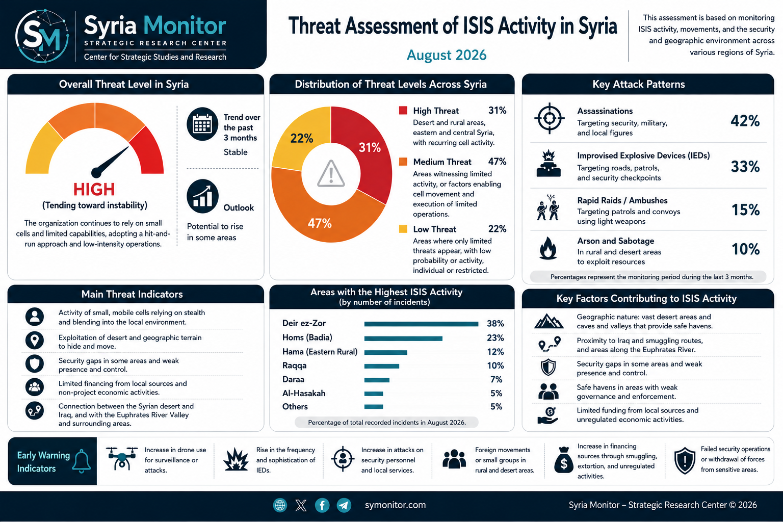
Syria Monitor – Strategic Research Center presents an assessment map of threat levels associated with ISIS activity in Syria during August 2026. The assessment is based on an analysis of the organization’s activity, the locations of monitored attacks and security incidents, areas of cell movement, and the geographic and security characteristics of different regions.

The map does not represent areas under actual ISIS control, nor does the classification of particular areas at different threat levels indicate a permanent military presence by the organization. Rather, it reflects an analytical assessment of the likelihood of cell activity, their ability to move and conduct operations, and their capacity to exploit security gaps.

The assessment is based on a range of indicators, including the frequency of attacks, assassinations, and improvised explosive device (IED) incidents; information regarding the presence and movement of cells; terrain characteristics; the extent of desert and rural areas; potential movement routes; and the level of security stability and deployment.

The map shows clear variations in threat levels across eastern, central, western, and southern Syria, with open desert and rural areas remaining more conducive to cell movement than urban centers with a denser security presence.

Syria Monitor has adopted three primary threat levels:

Red – High Threat: Areas where stronger indicators exist of cell activity or the ability of cells to move and conduct operations.

Orange – Medium Threat: Areas that have recorded activity or contain conditions that could facilitate cell movement and limited operations, but where available indicators are insufficient to classify them as high-threat areas.

Yellow – Low Threat: Areas where the possibility of limited or individual activity remains, but where current indicators do not point to a high level of operational activity.

This assessment is subject to periodic updates as new information emerges or as the organization’s patterns of activity on the ground change.

Threat Assessment Methodology

In preparing its ISIS threat assessment map for Syria, Syria Monitor relies on a combination of security, field-based, and geographic indicators designed to assess the level of threat in each area rather than relying solely on the number of recorded attacks.

The assessment is based on cumulative monitoring of ISIS activity, cell movements, and security incidents linked or suspected to be linked to the organization, alongside an analysis of the characteristics of areas that facilitate cell movement, concealment, and operational activity.
Assessment Indicators

The threat-level assessment is based on five primary indicators:

1. Operational Activity:
The number, frequency, and nature of recorded attacks, as well as the types of targets involved. Greater weight is given to areas where operations recur within relatively short periods.

2. Presence and Movement of Cells:
Field information concerning the presence of active cells or individuals linked to the organization, as well as indicators suggesting that certain areas are being used for movement, concealment, or logistical support.

3. Geographic Characteristics:
Desert, mountainous, and open rural areas are generally more conducive to cell activity than urban centers, particularly where caves, valleys, and extensive terrain make continuous security monitoring difficult.

4. Level of Security Presence and Control:
Threat levels increase in areas characterized by limited security deployment, the presence of multiple security or military actors, or extensive territory that is difficult to secure on a permanent basis.

5. Movement Routes and Geographic Connectivity:
The assessment considers the importance of certain areas as potential corridors linking the Syrian Badia with the Euphrates Valley and the Iraqi border, as well as routes connecting desert areas with population centers.

Threat Levels

The areas shown on the map are divided into three threat levels:

High Threat – Red:
Areas where strong indicators point to cell activity or an ability to move and conduct operations, or where geographic and operational conditions allow ISIS to maintain persistent or recurring activity.

Medium Threat – Orange:
Areas where indicators suggest limited activity or a potential capacity for cells to conduct operations, but where the level of activity and freedom of movement remains below that observed in high-threat areas.

Low Threat – Yellow:
Areas that may experience isolated incidents or limited activity, but where current indicators do not demonstrate a high operational capability or sustained ISIS activity.

Classifying an area at a particular threat level does not mean that the entire geographic area experiences the same degree of activity. Rather, the classification reflects an overall threat assessment within the geographic zone identified on the map.

Threat levels may also change in response to developments in operational activity, shifts in the security environment, cell movements, and the results of military and security operations targeting the organization.

Overview of the ISIS Threat in Syria

Monitoring data indicate that the ISIS threat in Syria during August 2026 is not characterized by contiguous territorial presence or direct control over specific areas. Instead, it relies primarily on a network of small, dispersed cells capable of moving and carrying out limited operations across geographically separated areas.

The Syrian Badia and eastern Syria remain the most significant geographic environment for the organization. Vast desert areas and rugged terrain provide conditions that facilitate concealment and movement away from major population centers.

The Badia, extending between central and eastern Syria, constitutes an important environment for cell movement, particularly along routes leading toward Deir ez-Zor, the Euphrates Valley, and areas near the Syrian-Iraqi border. This does not indicate actual ISIS control over these areas; rather, the terrain provides more favorable conditions for small groups to remain concealed, move, and reposition.

A different pattern is evident in cities and populated areas. In Deir ez-Zor, Raqqa, Daraa, and other locations, the threat is more closely associated with assassinations, IED attacks, and rapid hit-and-run operations that can be carried out by a limited number of operatives without requiring a visible military presence.

Operations monitored during the recent period have continued to target security and military personnel, local figures, patrols, vehicles, and security positions. This pattern reflects the continued use of an attritional strategy rather than an attempt to seize and hold territory.

Geographic Distribution of the Threat

The current threat landscape can broadly be divided into three patterns:

Eastern and Central Syria:
These areas represent the most sensitive geographic zone due to the connection between the Badia, the Euphrates Valley, and the Iraqi border, in addition to the presence of vast areas where maintaining continuous security surveillance remains difficult.

Western, Northern, and Southern Syria:
The threat is more dispersed in these areas and is primarily associated with the possibility of small-cell activity, assassinations, IED attacks, and other limited operations. Current indicators do not suggest a broad or contiguous ISIS presence.

Urban Centers:
ISIS has a limited ability to maintain an overt presence in major urban areas. Nevertheless, this does not eliminate the threat posed by clandestine cells or individual operatives capable of conducting low-cost attacks that are difficult to prevent entirely.

Accordingly, the current ISIS threat in Syria can be characterized as geographically uneven: it is higher in certain desert and eastern areas, lower in others, while the possibility of limited attacks remains present outside the organization’s primary areas of activity.